
Nepal is the Himalayan country. It is the home to the many of the mountains including some of the tallest in the world and the Everest itself. With all the mountains, Nepal offers the best trail for trekking. Thousands of tourist pay visit to Nepal for trekking. Everest Base Camp, Annapurna Circuit trek, Annapurna Base Camp, Upper Mustang trek, Manaslu Circuit trek are some of the popular trekking destinations of Nepal.
About Manaslu Circuit Trek
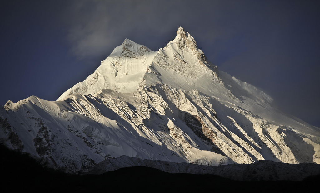
Manaslu Circuit Trek is one of the popular trekking routes of Nepal. In this circuit trek, you will see the amazing view of Mount Mansalu which stands at an elevation of 8,163 meters above the sea level, the Ganesh Himal Range and several other peaks too. You will also pass through the distinctive villages which are mainly influenced by Tibetan culture. This circuit trekking is popular because it provides the mesmerizing view of the snow-covered mountains of the Himalayas and also gives you the opportunity to get to know the people of different ethnic background who live in the hill villages and are scattered along the trekking route.
This trek will take you to the region of Mount Manaslu, which is also known as Khutang and it is the eighth tallest mountain of the world located in Gorkhadistrict of Nepal. The word “Manaslu” comes from Sanskritand it means “mountain of the spirit.” In Tibetan language, Manasluis known as “Kutan I” in which “tan” means flat place In Tibetan. Manaslu offer the several routes for the Mountaineers as it has favorable topography with long ridges and glacial valleys. There are mountains which surround Manaslu, which includes Ngadi Chuli, Himalchuli and Baudha. Larke Pass, which is the highest point of the whole circuit trek lies at an elevation of 5,106 meters is at the northern side if Manaslu. In the east there is Ganesh Himaland the Budhi Gandaki River gorge on the west by the deep fissures of the Marysyangdi Khola with its Annapurna range of hills to the south is the beautiful town of Gorkha.
The trekking is Manaslu has various trekking options. The most popular trekking route is of 177 meters that skirts the Manaslu massif over the pass down of the Annapurna massif. You will also pass through the ancient salt trading route along the river of Budhi Gandaki. There are ten peaks which height exceeds over 6,500 meters/21,300 feet, and also you will get a view of mountains over 7,000 meters/23,000 feet.

More about Manaslu region
Along with the beautiful mountains surround the Manaslu region, it is also very rich in culture which is very distinctive and unique. Mainly there are two ethnic groups; Nubri and Tsum. The river at Chhikur divides these ethnic groups. The village of Nubri is frequently visited by the by tourist after Nepal opened itself to the tourism since the year 1950. While Tsum still has kept up its traditional art, culture,and tradition.Gurungs has inhabited in the central hills of the region. Other ethnic groups are Bhutais (also spelled as Bhotias) and Sherpas. As this region mostly comprises people following Buddhism, there are many monasteries, mani walls, chortens, and other Buddhists religious sites.
Manaslu region is also very rich in wildlife and vegetations. Many highly endangered animals resides in this region including snow leopards and red pandas. Other wildlife that can be found includes are a lynx, grey wolf, Asian black bear, Himalayan goral, woolly hare, horseshoe bat, black-lipped pika,and Himalayan mouse hare. In total there are 110 species of birds, 33 mammals, 11 butterflies, and three reptiles. For the protection, preservation,and conservation of wildlife, there isa hunting ban in this region. About the vegetation of this region, there are 19 different types of forest, most of them being dominated by rhododendron and Himalayan blue pine. There are important plants which have medicinal use,and there are aromatic plants as well. In total there are about 1,500-2,000 species of plant that grows in this region.
Also, Manaslu is declared as Manaslu conservation Area in the year 1998 in December under the National Parks and Wild Life Conservation Act. The conservation zone covers the total area of 1,663 square kilometers,and it is managed by the National Trust for Nature (NTNC) of Nepal. In the Manaslu area, the status of “conservation area” is applied so as “to conserve and sustainable management of the natural resources and rich cultural heritage and to promote ecotourism to improve the livelihood of the local people in this region.”

Making all the way to Manaslu Circuit Trek
Your actual trekking starts from Arughat (570 meters). To arrive at Arughat, you can take a bus ride from Kathmandu through the Kathmandu-Pokhara Highway which takes about 8 hours of driving. You will enjoy the drive as you will pass by the beautiful view of mountains like Ganesh Himal and Manaslu. While trekking you can take camping equipments and stay overnight in various villages and valleys. It will bring you closer to the life of Himalayas and helps in sustainable tourism by providing jobs of guides and porters to the locals of Himalayas. You will also get chance to see the exotic plants of animals of Manaslu region which promotes in ecotourism.
So, starting your trekking from Arughat, you will pass by the bazaars with small shops and filled with locals. You will walk the bridge over the river of Budhi Gandaki. You will trek along the bank of Budhi Gandaki, through terraces, villages, green hills, interesting water streams and delightful. You will reach a village called Sante Bazaar (630 meters) from where you can see the magnificent view of SringeriHimal which is at an elevation of 7,187 meters. You will pass by some small village of Magar and Gurung ethnicity as well. Then you will arrive at Soti Khola (710 meters), where you can put up a camp and have an overnight stay.
From Soti Khola, you will trek to Labu Besi (880 meters). In your trail, you will cross a bridge, then walk past the beautiful forest of sal. You will also climb up onto a ridge above the huge rapids of Budhi Gandaki River. The trails are rocky, narrow as well. Then eventually the trail makes it way down and then you will arrive at LabuBesi, which is a typical Gurung village.
Then from Labu Besi, you will trek to Doban, which is at an elevation of 1,000 meters. This trail will take you through some ups and down. You will climb over a ridge to a village called Maccha Khola. Then crossing Tharo Khola and reach to Khorla Besi. From Khorla Besi, you will climb over a small ridge and reach Tatopani. Tatopani is a popular spot, which means “hot water.” As the name suggests, in Tatopani you can enjoy the natural hot water bath. Then from Tatopani, you will climb another ridge and cross Budhi Gandaki and climb the staircase over the ridge of Doban.
From Doban, you will move to Jagat (1,410 meters). You will cross a suspension bridge over the Yaru Khola, climb some stairs, pass by some villages and reach to Jagat, which is a beautiful flagstone village. In there you will find an excellent camping site, and there is another too below the village by Bhalu Khola. From Jagat, Ngyak Bensi (2,300 meters) comes next. The trail offers a climb over a rocky ridge to a village called Salleri, from where you can have the view of beautiful Shringi Himal and ease up a bit. Then descending you will continue the trek to the stone houses of Ghatta Khola. There is an old trail that follows up to Pangsing that climbs to Ngyak, which is one of the few large settlements on this route and there also lies the office of Manaslu Conservation Area Project. You can get to see the beautiful view of Mount Lapuchun (5,950 meters).
Now, you will move to Ghap. The trail will take you to the beautiful pine trees route, heavily forested areas in a narrow valley, bamboo forest and some of the distinctive villages. The trail will be of more ups and downs through the forest from where you will see the view of Manaslu Massif and then you will reach Ghap. From Ghap, you will pass a few houses, streams, forest, where you might see the national bird of Nepal, Danphe and wooden bridges over the gorges. You will also walk past rhododendron and bamboo forest. Then arrive at Namrung (2,660 meters), which is a Buddhist village with monasteries, chortens, prayer flags,a water turbine, and hydroelectricity powerhouse as well.
From Namrung comes Samagaon (3,530 meters). Samagaonis influenced by the Tibetan culture where there are mani walls, chortens,and monasteries. You will also see the view of Mount Manaslu and Kutang Himal Massif. Samdo comes to next Samagaon, which is at an elevation of 3,860 meters. Samdo is a Tibetan refugee site camp where you can see the lifestyle and culture of Tibetan people along with enjoying the view of beautiful mountains around. Then comes Dharamshala (4,480 meters) and then Bimtang (3,720 meters). In this trail, you will cross the highest point of this circuit in Larke Pass, which is at an elevation of 5,213 meters. A steep descent follows the trail of Larke Pass towards Salpudanda glacier. You will get to see the view of Himlung Himal, Cheo Himal, Kang Giru, Gyaji Kung and Annapurna II. Then, you will move to Tilje (2,300 meters) and Tal (1,700 meters). From Tal, you can get the transportation facility, and you can take a bus back to the Kathmandu.